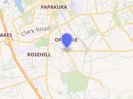
Ōpaheke
Ōpaheke is a suburb of Auckland, in northern New Zealand. It is located to the south of Papakura, and 32 kilometres south of Auckland CBD. The suburb makes up the southernmost part of the Auckland metropolitan area.
Ōpaheke | |
|---|---|
Suburb | |

| |
| Country | New Zealand |
| Local authority | Auckland Council |
| Electoral ward | Manurewa-Papakura Ward |
| Local board | Papakura Local Board |
| Population (2018) | |
| • Total | 2,868 |
| Train station(s) | Papakura railway station |
| Pahurehure | Papakura | Red Hill |
| Rosehill |
|
Hunua |
| Drury | Drury | Ponga |
The New Zealand Ministry for Culture and Heritage gives a translation of "place of a landslide" for Ōpaheke.[1]
History
Ōpaheke became recognised as an independent suburb in 1989. The previous area was referred to as a small area of greater Papakura, but has now developed into a separate residential area.
During the major reformation of local government, also in 1989, the Ōpaheke area was included into the Papakura District boundaries.
Since October 2010, after a review of the Royal Commission on Auckland Governance, the entire Auckland Region was be amalgamated into a single city authority. As well as the former Papakura District, all other territorial authorities have been abolished and the entire area has been dissolved into a single Auckland city council. The suburb of Ōpaheke has been in the Manurewa-Papakura Ward of the Auckland Council since.
Demographics
| Year | Pop. | ±% p.a. |
|---|---|---|
| 2006 | 2,553 | — |
| 2013 | 2,592 | +0.22% |
| 2018 | 2,868 | +2.04% |
| Source: [2] | ||
Ōpaheke had a population of 2,868 at the 2018 New Zealand census, an increase of 276 people (10.6%) since the 2013 census, and an increase of 315 people (12.3%) since the 2006 census. There were 903 households. There were 1,398 males and 1,473 females, giving a sex ratio of 0.95 males per female. The median age was 33.7 years, with 627 people (21.9%) aged under 15 years, 624 (21.8%) aged 15 to 29, 1,332 (46.4%) aged 30 to 64, and 285 (9.9%) aged 65 or older.
Ethnicities were 71.0% European/Pākehā, 24.5% Māori, 9.6% Pacific peoples, 11.3% Asian, and 2.8% other ethnicities (totals add to more than 100% since people could identify with multiple ethnicities).
The proportion of people born overseas was 22.8%, compared with 27.1% nationally.
Although some people objected to giving their religion, 49.5% had no religion, 35.8% were Christian, 2.1% were Hindu, 0.7% were Muslim, 0.7% were Buddhist and 5.1% had other religions.
Of those at least 15 years old, 429 (19.1%) people had a bachelor or higher degree, and 405 (18.1%) people had no formal qualifications. The median income was $39,700. The employment status of those at least 15 was that 1,338 (59.7%) people were employed full-time, 252 (11.2%) were part-time, and 84 (3.7%) were unemployed.[2]
Education
Opaheke School is a coeducational full primary school (years 1–8) with a roll of 579 as of March 2020.[3][4] The school was founded in 1968.[5]
See also
External links
- Papakura District Council
- New Auckland Council
- Photographs of Opaheke held in Auckland Libraries' heritage collections.
References
- "1000 Māori place names". New Zealand Ministry for Culture and Heritage. 6 August 2019.
- "Statistical area 1 dataset for 2018 Census". Statistics New Zealand. March 2020. Ōpaheke (164000). 2018 Census place summary: Ōpaheke
- "New Zealand Schools Directory". New Zealand Ministry of Education. Retrieved 26 April 2020.
- Education Counts: Opaheke School
- "Our History". Retrieved 24 September 2020.