Ammerstol
Ammerstol is a village, part of the municipality of Krimpenerwaard in the Netherlands. It is located about 12 kilometres (7.5 mi) southeast of Gouda, on the Lek River.
Ammerstol | |
|---|---|
Village | |
 Flag  Coat of arms | |
| Coordinates: 51°55′39″N 4°48′31″E | |
| Country | Netherlands |
| Province | South Holland |
| Municipality | Krimpenerwaard |
| Population (2009) | 1,544 |
Between 1817 and 1985, Ammerstol was an independent municipality.[1] Until 2015, it was part of Bergambacht.
Ammerstol has two listed Rijksmonuments: the 17th century inventory of its Reformed Church (itself built during 1880-81), and a thatched-roof farmhouse.[2]
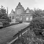
 The former post office in Ammerstol
.jpg.webp) Ammerstol's Reformed Church
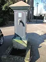
Ammerstol's Reformed Church Village pump on the Kerkplein
References
- Ad van der Meer and Onno Boonstra, Repertorium van Nederlandse gemeenten, KNAW, 2011.
- See NL language List of Rijksmonuments in Ammerstol
| Wikimedia Commons has media related to Ammerstol. |
External links
- J. Kuyper, Gemeente Atlas van Nederland, 1865-1870, "Ammerstol". Map of the former municipality, around 1868.
This article is issued from Wikipedia. The text is licensed under Creative Commons - Attribution - Sharealike. Additional terms may apply for the media files.