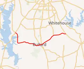
Farm to Market Road 344
Farm to Market Road 344 (FM 344) is a 18.126-mile (29.171 km) farm to market road located in Smith County, Texas.[1]
| ||||
|---|---|---|---|---|

| ||||
| Route information | ||||
| Maintained by TxDOT | ||||
| Length | 18.126 mi[1] (29.171 km) | |||
| Existed | 1945–present | |||
| Major junctions | ||||
| West end | ||||
| East end | ||||
| Location | ||||
| Counties | Smith | |||
| Highway system | ||||
| ||||
Route description
The western terminus of FM 344 is at SH 155 in unincorporated Smith County, southwest of Noonday; the roadway continues to the west as FM 2661.[2] The route travels to the south and then east, through Teaselville and close to the Cherokee County line into Bullard, where it intersects US 69. FM 344 continues to the northeast, to the community of Walnut Grove, before turning to the east and ending at SH 110 northwest of Troup.[1]
History
FM 344 was designated on June 11, 1945, between Eureka (now part of Teaselville) and Bullard. The route was extended to its eastern terminus at SH 110 on February 17, 1947, and to its western terminus at SH 155 on December 17, 1952. A realignment of the western terminus on February 15, 1971 established the current routing.[1]
Major intersections
The entire route is in Smith County.
| Location | mi[3] | km | Destinations | Notes | |
|---|---|---|---|---|---|
| | 0.0 | 0.0 | Western terminus; continues as | ||
| Teaselville | 4.4 | 7.1 | |||
| | 8.4 | 13.5 | |||
| Bullard | 9.8 | 15.8 | |||
| 10.3 | 16.6 | ||||
| | 14.5 | 23.3 | |||
| | 18.1 | 29.1 | Eastern terminus | ||
| 1.000 mi = 1.609 km; 1.000 km = 0.621 mi | |||||
References
- Transportation Planning and Programming Division (n.d.). "Farm to Market Road No. 344". Highway Designation Files. Texas Department of Transportation. Retrieved 2011-01-11.
- Transportation Planning and Programming Division (2012). Texas County Mapbook (PDF) (Map) (2012 ed.). 1:120,000. Texas Department of Transportation. p. 553. OCLC 867856197. Retrieved 2011-01-11.
- Google (2011-01-05). "Overview map of Farm to Market Road 344 Distances Between Interchanges" (Map). Google Maps. Google. Retrieved 2011-01-05.
