Pennsylvania Route 325
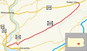
Pennsylvania Route 325 (PA 325) is a 30-mile-long (48 km) state highway located in Dauphin and Schuylkill Counties in Pennsylvania. The western terminus is at Riverview Road just past an interchange with U.S. Route 22 (US 22)/US 322 in the community of Speeceville in Middle Paxton Township. The eastern terminus is at US 209 in Tower City. PA 325 runs through a narrow valley for its length, passing through forested areas with some farmland. The route forms a concurrency with PA 225 to the north of Dauphin. The road was paved in stages between 1930 and the 1940s. PA 325 was designated in the 1940s to run between US 22/US 322/PA 14 in Speeceville east to US 209 in Tower City. In 1999, an interchange with US 22/US 322 was constructed near the western terminus; the end of PA 325 remained at Riverview Road, the former alignment of US 22/US 322.
| ||||
|---|---|---|---|---|
 | ||||
| Route information | ||||
| Maintained by PennDOT | ||||
| Length | 30.311 mi[1] (48.781 km) | |||
| Major junctions | ||||
| West end | Riverview Road in Middle Paxton Township | |||
| East end | ||||
| Location | ||||
| Counties | Dauphin, Schuylkill | |||
| Highway system | ||||
| ||||
Route description
PA 325 begins at an intersection with Riverview Road in the community of Speeceville in Middle Paxton Township, Dauphin County, heading east-northeast on two-lane undivided Mountain Road. Immediately after beginning, the route has an interchange with the US 22/US 322 freeway. The road runs through wooded areas with some homes and fields, running along the southern base of Peters Mountain. PA 325 comes to an intersection with PA 225, turning south-southeast to form a concurrency with that route on Peters Mountain Road. The road passes through agricultural areas before heading into woods, with PA 325 splitting from PA 225 by heading east on Clarks Valley Road. The route heads through forested areas, curving northeast before heading north-northeast into a narrow agricultural valley with some homes, paralleling Clark Creek. Farther east, the road heads into more dense forests, running between Peters Mountain to the north and Stony Mountain to the south. PA 325 continues into Rush Township and crosses the Appalachian Trail. The route passes along the northern shore of the DeHart Reservoir prior to continuing northeast through more forests. The road heads into another narrow agricultural valley with some homes and passes by Bendigo Airport.[2][3] The route crosses into Porter Township in Schuylkill County and turns north through more farmland with a few woods and residences. PA 325 heads into the borough of Tower City and becomes 10th Street, passing homes before ending at US 209.[2][4]
History
When Pennsylvania first legislated routes in 1911, present-day PA 325 was not given a number.[5] By 1930, the current alignment of the route was an unnumbered road between north of Dauphin and Tower City, with the western section of the road paved.[6] In the 1930s, a section of the road west of Tower City was paved while a section leading east to the Clark Valley Dam was upgraded to an improved road.[7] PA 325 was designated in the 1940s to run from an intersection with US 22/US 322/PA 14 in Speeceville east to US 209 in Tower City. At this time, the entire length of the route was paved.[8] US 22/US 322 was upgraded to a freeway at the western terminus of PA 325 in 1999, with an interchange constructed.[9][10] The western terminus of PA 325 remained at the former alignment of US 22/US 322 at Riverview Road.[9][11]
Major intersections
| County | Location | mi[1] | km | Destinations | Notes |
|---|---|---|---|---|---|
| Dauphin | Middle Paxton Township | 0.000 | 0.000 | Riverview Road | Western terminus |
| 0.036– 0.045 | 0.058– 0.072 | Interchange | |||
| 3.409 | 5.486 | West end of PA 225 concurrency | |||
| 4.140 | 6.663 | East end of PA 225 concurrency | |||
| Schuylkill | Tower City | 30.311 | 48.781 | Eastern terminus | |
1.000 mi = 1.609 km; 1.000 km = 0.621 mi
| |||||
See also
 U.S. Roads portal
 Pennsylvania portal
References
- Bureau of Maintenance and Operations (January 2016). Roadway Management System Straight Line Diagrams (Report) (2016 ed.). Pennsylvania Department of Transportation. Retrieved August 29, 2016.
- Dauphin County (PDF)
- Schuylkill County (PDF)
- Google (June 12, 2011). "overview of Pennsylvania Route 325" (Map). Google Maps. Google. Retrieved June 12, 2011.
- Dauphin County, Pennsylvania Highway Map (PDF) (Map). PennDOT. 2011. Archived from the original (PDF) on November 6, 2011. Retrieved June 12, 2011.
- Schuylkill County, Pennsylvania Highway Map (PDF) (Map). PennDOT. 2011. Retrieved June 12, 2011.
- Map of Pennsylvania Showing State Highways (PDF) (Map). Pennsylvania Department of Highways. 1911. Archived from the original (PDF) on July 5, 2011. Retrieved January 1, 2014.
- Tourist Map of Pennsylvania (PDF) (Map). Pennsylvania Department of Highways. 1930. Archived from the original (PDF) on July 5, 2011. Retrieved June 24, 2010.
- Official Road Map of Pennsylvania (PDF) (Map). Pennsylvania Department of Highways. 1940. Archived from the original (PDF) on July 5, 2011. Retrieved June 24, 2010.
- Official Road Map of Pennsylvania (PDF) (Map). Pennsylvania Department of Highways. 1950. Archived from the original (PDF) on July 5, 2011. Retrieved January 1, 2014.
- General Highway Map Dauphin County, Pennsylvania (PDF) (Map). Pennsylvania Department of Transportation. 2002. Retrieved October 23, 2015.
- Federal Highway Administration (2012). "NBI Structure Number: 000000000041121". National Bridge Inventory. Federal Highway Administration.
- General Highway Map Dauphin County, Pennsylvania (PDF) (Map). Pennsylvania Department of Transportation. 1999. Retrieved October 23, 2015.
