Vermont Route 315
Vermont Route 315 (VT 315) is a 5.83-mile-long (9.38 km) state highway located within the town of Rupert in Bennington County, Vermont, United States. It connects VT 153 in Rupert to VT 30 in the village of East Rupert. The entirety of VT 315 is maintained by the town of Rupert.
| ||||
|---|---|---|---|---|
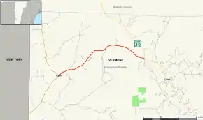
 Map of Bennington County in southwestern Vermont with VT 315 highlighted in red | ||||
| Route information | ||||
| Maintained by the Town of Rupert | ||||
| Length | 5.83 mi[1] (9.38 km) | |||
| Major junctions | ||||
| West end | ||||
| East end | ||||
| Location | ||||
| Counties | Bennington | |||
| Highway system | ||||
State highways in Vermont
| ||||
Route description

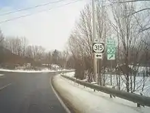
Eastern terminus of Route 315 at Route 30
VT 315 begins in the west at an intersection with VT 153. VT 153 southbound from this intersection provides a connection with New York State Route 22 and also runs northbound, paralleling the state border with New York to provide a more northerly connection with NY 22. VT 315 proceeds to the east, running through a generally isolated area, and ending at VT 30 in East Rupert.[2]
Major intersections

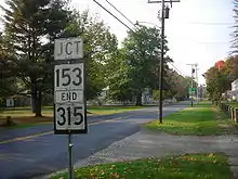
The western terminus of Route 315 at Route 153 in Rupert
The entire route is in Rupert, Bennington County. [1]
| mi[1] | km | Destinations | Notes | ||
|---|---|---|---|---|---|
| 0.00 | 0.00 | Western terminus | |||
| 5.83 | 9.38 | Eastern terminus | |||
| 1.000 mi = 1.609 km; 1.000 km = 0.621 mi | |||||
References
- Traffic Research Unit (May 2012). "2011 (Route Log) AADTs for Major Collectors" (PDF). Policy, Planning and Intermodal Development Division, Vermont Agency of Transportation. Retrieved April 25, 2015.
- Google (November 13, 2015). "overview map of Vermont Route 315" (Map). Google Maps. Google. Retrieved November 13, 2015.
This article is issued from Wikipedia. The text is licensed under Creative Commons - Attribution - Sharealike. Additional terms may apply for the media files.
