Interstate 685
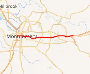
Interstate 685 (I-685), is the designation for a future Interstate Highway in the U.S. state of Alabama. When completed, it will connect I-65 in downtown Montgomery to I-85 in the eastern suburbs of Montgomery. The routing is currently signed as I-85.
| ||||
|---|---|---|---|---|

Future I-685 highlighted in red | ||||
| Route information | ||||
| Maintained by ALDOT | ||||
| Length | 15.011 mi[1] (24.158 km) | |||
| History | Designation approved in 2010 | |||
| Major junctions | ||||
| West end | ||||
| East end | ||||
| Location | ||||
| Counties | Montgomery | |||
| Highway system | ||||
| ||||
Route description
Currently, I-685 has been approved by the American Association of State Highway and Transportation Officials (AASHTO) to be co-signed with the current I-85 from its current southern terminus at I-65, to the future location of the Montgomery South Bypass on which I-85 will be rerouted.[2] The open section of Future I-85 is temporarily designated as State Route 108.
Interstate 685 is currently Interstate 85.
History
The designation was approved in 2010 at the request of the Alabama Department of Transportation (ALDOT) to use existing I-85.[2] Construction on the Montgomery Outer Loop started in early 2011, and the first part of it was completed in February 2016.[3] When done, the I-85 designation will be shifted to the Outer Loop, and the existing freeway will become just I-685.[4] This will be the first auxiliary interstate of Interstate 85 that starts with a six.[5]
Exit list
The entire route is in Montgomery, Montgomery County.
| mi[1][6] | km | Exit | Destinations | Notes | ||
|---|---|---|---|---|---|---|
| 0.000 | 0.000 | — | Southern terminus; I-65 exit 171; no access from eastbound Day Street to southbound I-65 or from northbound I-65 to Day Street; future western terminus of I-685 | |||
| 0.790 | 1.271 | 1 | Court Street | Northbound exit and southbound entrance | ||
| 1.290 | 2.076 | 1 | Union Street | Southbound exit and northbound entrance | ||
| 2.130 | 3.428 | 2 | Forest Avenue | Northbound exit and southbound entrance | ||
| 2.320 | 3.734 | 2 | Mulberry Street | Southbound exit and northbound entrance | ||
| 3.004 | 4.834 | 3 | Ann Street | |||
| 4.734 | 7.619 | 4 | Perry Hill Road | |||
| 6.546 | 10.535 | 6 | Southern end of US 80 / SR 8 concurrency | |||
| 9.037 | 14.544 | 9 | Auburn University at Montgomery | |||
| 11.009 | 17.717 | 11 | ||||
| 15.011 | 24.158 | 15 | Future I-85 rerouting; future eastern terminus of I-685 | |||
| 1.000 mi = 1.609 km; 1.000 km = 0.621 mi | ||||||
See also
 United States portal
 U.S. roads portal
References
- Alabama Department of Transportation. "Milepost Maps" (PDF). Retrieved May 22, 2020.
- Special Committee on U.S. Route Numbering (October 29, 2010). "Report to the Standing Committee on Highways" (PDF) (Report). Washington, DC: American Association of State Highway and Transportation Officials. Archived (PDF) from the original on October 16, 2017. Retrieved December 13, 2011.
- Burylo, Rebecca (January 25, 2016). "1st phase of Montgomery's Outer Loop opens". The Montgomery Advertiser. Retrieved October 26, 2019.
- "Montgomery Outer Loop's first phase complete; ribbon cutting ceremony set". WSFA 12 News. January 25, 2016. Retrieved October 26, 2019.
- Shryock, John. "Outer Loop construction about to restart". Montgomery, AL: WSFA-TV. Retrieved December 13, 2011.
- Alabama Department of Transportation. "General Highway Maps" (PDF). Retrieved May 22, 2020.
.svg.png.webp)